

PUBLICATIONS LIST
*Corresponding author
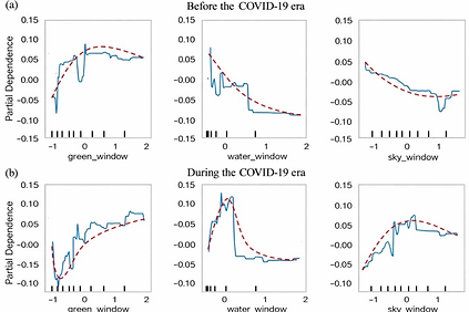
80. Liu, D., Wei, D., Ho, H. C., Li, M., & Lu, Y. (2026). Linking window-view nature exposure with health and wellbeing outcomes: Using photorealistic 3D city models and computer vision technique. Landscape and Urban Planning, 270, 105601. (Click for full text of PDF)
It is well established that nature exposure can improve both physical and mental health and wellbeing outcomes. However, in the context of rapid urbanization and high-density urban development, many urban residents face limited opportunities to visit natural environment, such as urban parks, greenways, and water bodies. In such situations, window view often serves as the primary means of people’s nature exposure. Traditional methods of assessing window-view nature exposure are time-consuming and labor-intensive, thus impractical for citywide evaluations. This study used a novel approach to quantify citywide assessment of window-view nature exposure, including the Window Greenery Index (WGI), Window Water Index (WWI), and Window Sky Index (WSI), using photorealistic 3D city models. We further analyzed the non-linear associations between window-view nature exposure with physical and mental health and wellbeing among 1,660 participants in Hong Kong for two periods: before and during the COVID-19 pandemic. For comparison, street-level nature exposure was also assessed. The result illustrates spatial mismatch between window-view and street-view nature exposure. Furthermore, window-view nature exposure had a greater influence than street-view nature exposure on physical and mental health and wellbeing. Furthermore, the effect of window-view nature exposure becomes more pronounced during the COVID-19 pandemic than before the pandemic. The results shed light on the link between window-view nature exposure and health and wellbeing outcomes, providing a new research front to understand the joint impacts of urban planning (i.e., provision of green space) and architectural design (i.e., location and orientation of windows) on public health.




79. Li, Z., Lu, Y., Wang, J., & Wu, Y. (2026). Rail transit and travel satisfaction: Evidence from a natural experiment in Wuhan. Travel Behaviour and Society, 43, 101211. (Click for full text of PDF)
The impact of rail transit infrastructure on residents’ travel satisfaction and subjective well-being has gained increasing attention among researchers and policymakers. However, few studies have used longitudinal data to analyze the causal effects of rail transit systems on travel satisfaction and its underlying mechanisms. This study employed a natural experiment approach, using two waves of survey data (2020 & 2021) from 422 participants in Wuhan, China, to assess the effects of a newly opened subway line on travel satisfaction. Applying a mixed-effects difference-in-differences (DID) method, we found that the new subway line significantly improved residents’ travel satisfaction after accounting for socio-demographic and travel attitude covariates. Mediation analysis revealed that this improvement was primarily driven by increased perceived accessibility to downtown and transit stops or stations, as well as a reduction in the number of out-of-home activities on weekends. Heterogeneous analysis indicated that the subway’s benefits are more pronounced among females, individuals under 60 years old, and those from middle-income households. These findings provide new causal evidence on the link between rail transit infrastructure and travel satisfaction, deepening our understanding of this complex relationship and offering practical insights for formulating strategies to improve urban residents’ quality of life.

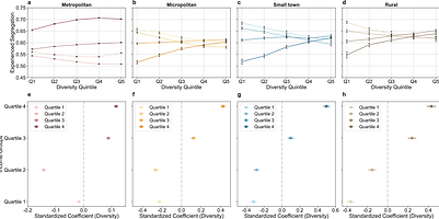
78. Zhou, Y., & Lu, Y. (2025). Varying relationships between experienced income segregation and travel behaviour across neighbourhood social and urban contexts. Nature Communications, 16(1), 11236. (Click for full text of PDF)
Income segregation is a barrier to social inclusivity and equity. It is affected by individuals’ travel behaviour and socioeconomic status and may be intensified by localised living models emphasising conducting daily activities within immediate neighbourhoods. However, how the relationship between experienced income segregation and travel behaviour varies across neighbourhood social and urban contexts remains unclear. Here, we quantify experienced income segregation using a dataset of 1.2 billion mobility records from the contiguous United States and examine its relationships with travel distance and diversity across neighbourhoods with different social and urban contexts. We find that longer travel distances and more diverse destinations are associated with less experienced segregation for least affluent neighbourhoods, especially in less urbanised areas. Our findings underscore the need for urban planning and transport interventions to increase mobility and social integration opportunities for residents from socially disadvantaged neighbourhoods. They also highlight the potential adverse social consequences of localised living models.


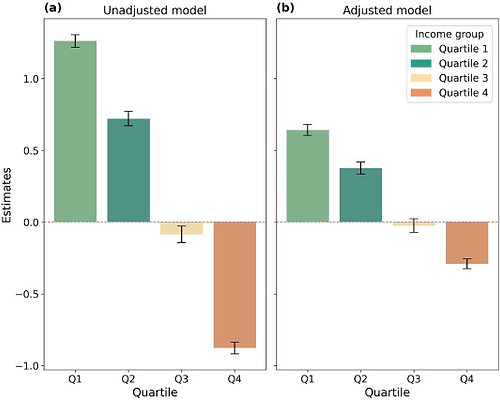
77. Zhou, Y., & Lu, Y. (2025). Experienced economic segregation and associated mental health inequalities across urbanicity. Social Science & Medicine, 118813. (Click for full text of PDF)
The global mental health burden is rising, with economic segregation as a key social determinant contributing to mental health and its inequalities. However, most studies rely on residential-based segregation measures failing to capture the actual segregation individuals experience through daily mobility and activities. Using a large-scale mobility dataset across the contiguous United States, we quantify mobility-based economic segregation and examine its associations with mental health outcomes across income groups and urbanicity levels. We find that individuals in the lowest and highest income quartiles exhibit strong self-segregation. A 0.1-unit increase in economic segregation is observed to be associated with a 0.64 % (95 % CI: 0.60 %–0.68 %) rise in poor mental health prevalence among lowest income quartile groups and a 0.29 % (95 % CI: 0.26 %–0.32 %) decline among highest income quartile groups in metropolitan areas. In less urbanized areas, the adverse mental health impacts of mobility-based economic segregation remain significant for low-income groups, while no significant health impact is observed for high-income groups. These findings suggest that mobility-based economic segregation may intensify economic disparities in mental health outcomes. Interventions that enhance upward social mixing for low-income individuals through changes in their mobility may help reduce adverse impacts of economic segregation on mental health and mitigate associated inequalities.

76. Liu, F., Lu, Y., Song, Q., Qiu, W., & Liu, D. (2025). The association of subjective physical disorder and pedestrian volume: A big urban data and machine-learning approach. Computers, Environment and Urban Systems, 122, 102348. (Click for full text of PDF)
Physical disorder in an urban area is characterized by visible damage, decay, and deterioration in its built environment, such as broken windows, graffiti, and litter. While its adverse effects on mental health, crime rates, and life satisfaction are well-documented, its impact on pedestrian volume–an essential indicator of urban vibrancy and livability–remains poorly discussed. Moreover, previous studies have predominantly relied on objective measures of physical disorder, overlooking subjective perceptions and potentially leading to biased interpretations. To address these crucial research gaps, we developed an online visual survey to evaluate the perceived physical disorder in Shanghai, China, across five dimensions: architectural disorder, commercial disorder, road disorder, greenery disorder, and infrastructure disorder. Then, we leveraged diverse machine learning algorithms to predict citywide spatial patterns of physical disorder based on both high-level street elements and low-level features. Finally, we examined the associations between urban physical disorder and pedestrian volumes, categorized by age and gender. Our findings reveal disparities in the influence of different types of subjective physical disorder on pedestrian volumes by demographic groups. Moreover, the subjective physical disorder provides a valuable supplement to existing built environment factors in explaining collective walking behavior. Notably, greenery disorder exhibits a significant negative association with walking behavior among female, adult, and elderly pedestrians, whereas infrastructure disorder predominantly impacts young pedestrians. Leveraging big data, this subjective measurement framework enables demographically sensitive evaluation systems of physical disorder as well as targeted interventions to reduce perceived physical disorder and improve walkability for different population groups.

75. Liu, D., Lu, Y., & Jiang, Y. (2025). Exploring the environmental justice of street tree provision: Adding biodiversity to automatic assessment of street-level greenery. Urban Forestry & Urban Greening, 129184. (Click for full text of PDF)
Tree species play a crucial role in enhancing environmental sustainability, public health, and social equity beyond the quantity of urban trees. Previous studies have identified the luxury effect (socioeconomic status) and legacy effect (i.e., historical development) as two primary drivers of spatial inequality of street trees diversity. Nevertheless, there is a lack of research examining the driving factors of street tree diversity inequality in the cities in China, which follow a centralized top-down urban development strategy, distinct from that in many Western cities. This study examines which effect, i.e., the luxury effect (measured by housing price) or legacy effect (measured by building ages) can explain environmental inequality of urban street tree diversity in a typical northern city, Jinan China. Drawing on advanced computer vision technology and prevalent Street View Images, this study automatically examines not only the quantity but also the species and other individual features of street trees. The study area includes both the old town with dense, low-rise buildings and newly built urban districts characterized by high-rise developments. We utilized Pearson correlation analysis and Principal Component Analysis (PCA) to elucidate the link of tree abundance, diversity, and other metrics with housing price and building ages. Our findings indicate that housing price shows no significant association with tree metrics. Instead, building age and the interactive effect of building age and housing price are positive linked with both quantity and biodiversity of street trees. These results highlight the importance of legacy effect in shaping urban street trees, while the luxury effect on street tree diversity is heterogeneous across areas developed in different times. These results confirm our hypothesis regarding the unique influence of China's centralized greening policies on urban forest composition. Our findings contribute to the political ecology discourse on environmental inequality and urban greenery distribution both locally and globally.


74. Zou, X., Lu, Y., & Zhou, Y. (2025). Threshold effects between spatial access to medical resources and life expectancy: a 19-year longitudinal study in Hong Kong. Social Science & Medicine, 118654. (Click for full text of PDF)
While the positive link between medical resource allocation and life expectancy has been widely explored, the threshold effects of spatial access to medical resources from a longitudinal perspective remain underexplored. Studying these threshold effects is important to improve urban medical resource allocation and to protect human health. We used official records from 41 public hospitals and applied the Enhanced Two-Step Floating Catchment Area (E2SFCA) method to measure the spatial access to medical professionals and medical services in 179 community-level planning units (STPUGs). We then used 727,802 valid mortality records in Hong Kong from 2000 to 2018 to test the link between medical resource accessibility and years of life lost (YLL). Our analysis revealed three key findings: (1) Better access to medical professionals and services is associated with higher life expectancy, and medical services have a stronger effect than medical professionals; (2) The relationships between spatial access to medical resources and life expectancy show non-linear patterns and threshold effects; (3) These relationships vary across different income groups. These results provide empirical evidence to improve medical resource allocation and to build equitable medical systems and sustainable social development.


73. Wu, X., Lu, Y., Wei, D., & Chen, W. Y. (2025). The racial inequity of park visitation behavior in the post-pandemic era. Travel Behaviour and Society, 41, 101105. (Click for full text of PDF)


The COVID-19 pandemic has exacerbated pre-existing racial disparities in park usage. Although numerous studies have reported a widened racial inequity in park visitation during the pandemic, it remains unclear how this inequity has dynamically evolved in post-pandemic era. In this study, using nationwide location-based mobile data from SafeGraph's Monthly Patterns dataset and the linear mixed effects model, we analyzed four-year longitudinal change (2018–2021) in park visitation behaviors among racially distinct neighborhoods and examined whether neighborhood greenness moderated these disparities in the United States. The results demonstrate that: (1) racial inequity in park visitation has continued to widen over the two-year pandemic period; (2) while park visitation across all groups has gradually returned to and even surpassed pre-pandemic levels, Black-majority groups consistently exhibited lower visit counts and fewer visited parks than Black-minority groups; and (3) neighborhood greenness significantly mitigates racial disparities in park visitation, with higher greenness levels associated with reduced inequity. These findings point out the potential impact of neighborhood greenness on alleviating racial inequity in park visits.
72. Liu, D., Lu, Y., Wei, D., & Hu, Y. (2025). Contrasting inequalities in collective residence-based and pedestrian-based urban greenery exposure with multi-sourced urban big data and deep learning. Applied Geography, 183, 103743. (Click for full text of PDF)
Urban greenery offers diverse benefits to city dwellers. Yet, traditional greenery exposure assessments, based on residential or workplace locations, may ignore the mobility patterns of humans, leading to inaccurate estimates and overlooked inequalities, especially for those with social disadvantages.
This study presented a novel approach to evaluate pedestrian-based greenery exposure (PBE) by estimating citywide pedestrian volumes across age groups using street-view imagery. We compared this method to the conventional residence-based greenery exposure (RBE) approach. Both top-down and eye-level metrics were used to measure urban greenery, resulting in four greenery exposure measures.
To compare inequalities in four types of greenery exposure across socioeconomic and demographic groups, this study analyzed the associations between income, age, and each greenery exposure type, while also calculating Gini coefficients to assess inequality across varying buffer sizes.
The study demonstrated a positive correlation between greenery exposure and median household income (indicated as “income” in the following part), indicating strong socioeconomic inequalities. The Gini index was higher for pedestrian-based exposure compared to residence-based exposure. Additionally, all forms of greenery exposure for older people exhibited lower mean values and Gini indices compared to all population. These findings indicated the importance of pedestrian-based measurement and a more fine-grained and multi-dimensional metric for evaluating inequality in greenery exposure.

71. Jiang, Y., Sun, Z., Wei, D., Zhao, P., Yang, L., & Lu, Y. (2025). Revealing the spatiotemporal pattern of urban vibrancy at the urban agglomeration scale: Evidence from the Pearl River Delta, China. Applied Geography, 181, 103694. (Click for full text of PDF)
Urban vibrancy research has largely focused on city-scale analysis, leaving urban agglomeration-level vibrancy underexplored. Using location-based service (LBS) data from the Pearl River Delta (PRD), China, this study quantified urban vibrancy through four indicators: density, variation intensity, day-night tide, and holiday-weekday tide. OLS and GWR models were employed to examine the relationships between built environment factors and urban vibrancy. The findings revealed distinct vibrancy patterns between core cities and fringe areas: core cities exhibited higher vibrancy density with lower temporal fluctuations than fringe areas. OLS results revealed that road density and distance to railway stations significantly influenced vibrancy density and variation intensity, while population density and GDP density were strongly linked to vibrancy density. Residential POI and NDVI significantly affected variation intensity. The GWR model highlighted spatial heterogeneity in how built environment factors impact vibrancy. This study provides insights into spatiotemporal vibrancy at the urban agglomeration scale, offering guidance for optimizing built environments to support balanced regional development.
